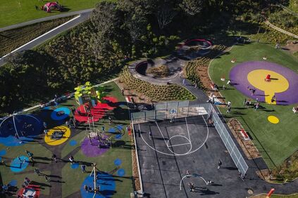
PUKEHUIA PARK
Opening ceremony
Wellington City Council and Taranaki Whānui ki Te Upoko o Te Ika, mana whenua, opened Pukehuia Park (formerly Newlands Park), on Saturday 31 July 2021. There are some photos of the opening ceremony here and here
Meaning of the name
Pukehuia translates as ‘hill of the huia bird’. ‘Huia’ are now sadly extinct native birds that were once prolific in Newlands. Pukehuia, was previously used to describe the area now known as Newlands.
What’s in the park
The park includes a wetland area, new walking tracks, skate park, basketball court, pump track play spaces for tamariki and rangatahi and Wellington’s first all-weather Ki-O-Rahi pitch!
We are currently working out how best residents can access Ki-O-Rahi gear. Here is a video link explaining the game ttps://www.r2r.org.nz/games-activities-maori-youth/ki-o-rahi.html .The rules are also sign posted at the Park.
The park has two gas powered BBQ’s which are free. Please clean after use. It will also be routinely serviced by The Council.
The Park has a site for a café and/or food truck. You don't need a food license for a charity or fundraising stall, as long as you operate less than 20 times a year, but you still need to get Council permission. Anyone wishing to use the site must comply with the Council regulations for trading in public spaces. There is more information here
Items of work in the Park that will complete post opening are:
● Skate fencing on the southern end of the skate park
● Staining of skate fencing and boundary timber fencing
● Artwork on outside of skate walls
● Lighting of pathway from Newlands Road to Robert Street - solar lights to be installed (currently experiencing shipping delays)
● CCTV camera
● Native planting in selected areas
● Repair of neighboring indoor bowling hall carpark surface
Fostering community energy
NPPA is working with the Council and other leaders in Newlands to find out how best to use the park to foster the community energy that is present. Our thinking so far is to identify opportunities and scheduled events of interest, either one off or routinely, to attract residents in one place, to have some fun, with a festival atmosphere and food.
If you are interested, please contact us here [email protected]
Council, in its 2017 Play Spaces Policy, committed to providing a network of dedicated play space spread relatively evenly across the city, with 66 percent of all residents located within a 600–metre or 10–minute walk of a neighbourhood playground, or 800 metres of a community playground. In that Policy Council decided to retire the Kenmore Street neighbourhood play area, at the time of development of a new community play area at and Newlands Park, being Pukehuia Park. Now Pukehuia Park is open.
On 11 August Council informed NPPA they:
On 12 August he NPPA have requested Council for an indication of their decision-making criteria, process, options consideration, and timing on the future use of Kenmore Park, the best location for the Newlands War memorial and any other plans they have for the recreation of Newlands residents.
Wellington City Council and Taranaki Whānui ki Te Upoko o Te Ika, mana whenua, opened Pukehuia Park (formerly Newlands Park), on Saturday 31 July 2021. There are some photos of the opening ceremony here and here
Meaning of the name
Pukehuia translates as ‘hill of the huia bird’. ‘Huia’ are now sadly extinct native birds that were once prolific in Newlands. Pukehuia, was previously used to describe the area now known as Newlands.
What’s in the park
The park includes a wetland area, new walking tracks, skate park, basketball court, pump track play spaces for tamariki and rangatahi and Wellington’s first all-weather Ki-O-Rahi pitch!
We are currently working out how best residents can access Ki-O-Rahi gear. Here is a video link explaining the game ttps://www.r2r.org.nz/games-activities-maori-youth/ki-o-rahi.html .The rules are also sign posted at the Park.
The park has two gas powered BBQ’s which are free. Please clean after use. It will also be routinely serviced by The Council.
The Park has a site for a café and/or food truck. You don't need a food license for a charity or fundraising stall, as long as you operate less than 20 times a year, but you still need to get Council permission. Anyone wishing to use the site must comply with the Council regulations for trading in public spaces. There is more information here
Items of work in the Park that will complete post opening are:
● Skate fencing on the southern end of the skate park
● Staining of skate fencing and boundary timber fencing
● Artwork on outside of skate walls
● Lighting of pathway from Newlands Road to Robert Street - solar lights to be installed (currently experiencing shipping delays)
● CCTV camera
● Native planting in selected areas
● Repair of neighboring indoor bowling hall carpark surface
Fostering community energy
NPPA is working with the Council and other leaders in Newlands to find out how best to use the park to foster the community energy that is present. Our thinking so far is to identify opportunities and scheduled events of interest, either one off or routinely, to attract residents in one place, to have some fun, with a festival atmosphere and food.
If you are interested, please contact us here [email protected]
Council, in its 2017 Play Spaces Policy, committed to providing a network of dedicated play space spread relatively evenly across the city, with 66 percent of all residents located within a 600–metre or 10–minute walk of a neighbourhood playground, or 800 metres of a community playground. In that Policy Council decided to retire the Kenmore Street neighbourhood play area, at the time of development of a new community play area at and Newlands Park, being Pukehuia Park. Now Pukehuia Park is open.
On 11 August Council informed NPPA they:
- will start removing the Kenmore Street play equipment from 30 August, remediate the area back to lawn and look to retain the furniture and bin. This will now be dependent at which alert level Wellington is at.
- are planning for the relocation of the Newlands War memorial (currently on Newlands Road), to Kenmore St.
On 12 August he NPPA have requested Council for an indication of their decision-making criteria, process, options consideration, and timing on the future use of Kenmore Park, the best location for the Newlands War memorial and any other plans they have for the recreation of Newlands residents.
Seton Nossiter Park
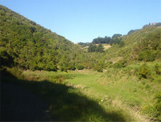
Seton Nossiter Park is the name for the area that used to be called Belmont Gully and it occupies 30 hectares of land which is now a protected natural reserve. The park's new name was recommended by the Council's Reserves Committee. It's development is part of the Northern Reserves Management Plan.
The Wellington City Council is trying to encourage the development of the park by creating walkways and footpaths so the public have more activities to do there. They are making reserves so that existing plants can grow more. Part of the park is scrub but they are trying to encourage the growth of such native trees as titoki, tawa, pukatea, hinau, kaiko-mako, mahoe and rewarewa. |
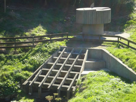
This picture shows the Flood Detention Area near the main entrance. |
Brandon's Rock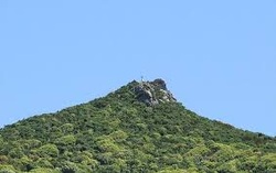
Brandon’s Rock, the highest point on the Paparangi ridge, and is a two-minute walk from Edgecombe Street, up a small hill, Brandon's rock has a stunning 360-degree view of the Tararua Range, the Hutt Valley, the harbour, Wellington City, Cook Strait and the skyline of the western hills. Next door is a Playground
Paparangi is the Māori name for the long ridge running from the entrance to Ngauranga Gorge to Horokiwi. The rock is named after Alfred de Bathe Brandon, who owned land in the Newlands area. Brandon arrived in 1840 and was a prominent lawyer, provincial councillor, parliamentarian and crown prosecutor. There were two unsuccessful attempts to mine gold on Brandon’s land and the property next door. Brandon’s Rock, known by sailors as the Nun’s Cap, was used as a navigation point before the introduction of harbour beacons. Ships entering the harbour could keep clear of Barrett Reef by staying east of a line from Brandon’s Rock to Point Gordon. Article on Brandon's Rock |
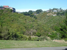
Gilberd Bush Reserve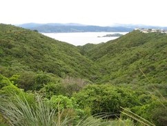
The track through the reserve has good views of the harbour, Matiu/Somes Island and the Orongorongo Range.
Gilberd Bush Reserve is in Newlands with entrance and exit points of Ladbrooke Drive, Bayswater Place and Fernhaven Grove. This bush-clad Newlands gully has a wide, well-formed track which gently zig-zags down from the highest point at Ladbrooke Grove, then crosses the gully to the entrances at Bayswater Place and Fernhaven Grove. It is a Well-graded track with a couple of steeper sections. Suitable for buggies. Wellington Walks Information CLICK HERE
|
